NEW: The September 2003 issue of Research Penn State features Ken
Davis' research on carbon dioxide concentration and transport above forests in
northern Wisconsin and the Upper Peninsula of Michigan. Visit:
http://www.rps.psu.edu/0309/breath.html for the full story.
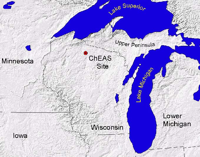
The Chequamegon Ecosystem-Atmosphere Study (ChEAS) is a multi-organizational research effort studying biosphere/atmosphere interactions within a northern mixed forest in Northern Wisconsin. A primary goal is to understand the processes controlling forest-atmosphere exchange of carbon dioxide and the response of these processes to climate change. Another primary goal is to bridge the gap between canopy-scale flux measurements and the global CO2 flask sampling network.
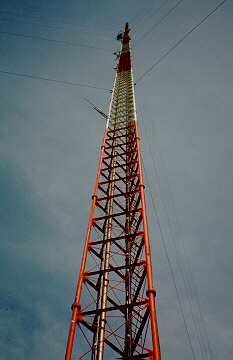
The ChEAS flux towers participate in AmeriFlux, and the region is an EOS-validation site. The WLEF tower is a NOAA-CMDL CO2 sampling site. ChEAS sites are primarily located within or near the Chequamegon-Nicolet National Forest in northern Wisconsin, with one site in the Ottawa National Forest in the upper peninsula of Michigan. Current studies observe forest/atmosphere exchange of carbon dioxide at canopy and regional scales, forest floor respiration, photosynthesis and transpiration at the leaf level and use models to scale to canopy and regional levels. EOS-validation studies quantitatively assess the land cover of the area using remote sensing and conduct extensive ground truthing of new remote sensing data (i.e. ASTER and MODIS). Atmospheric remote sensing work is aimed at understanding atmospheric boundary layer dynamics, the role of entrainment in regulating the carbon dioxide mixing ratio profiles through the lower troposphere, and feedback between boundary layer dynamics and vegetation (especially via the hydrologic cycle). Airborne studies have included include balloon, kite and aircraft observations of the CO2 profile in the troposphere.
STUDY AREA: The Chequamegon-Nicolet National Forest covers an area approximately 325,000 ha, and the dominant forest types are mixed northern hardwoods (85,000 ha), aspen (75,000 ha), and lowlands and wetlands (60,000 ha). Much of the area was logged, mainly for pine, during 1860-1920 and has since regrown. Human population density in the area is very sparse, approximately 5 people per square kilometer. The climate is cool continental, with a mean annual temperature of 4.1 C (-12.9 in January, 18.9 in July), and an average precipitation of 800 mm.
FUNDING:
National Institutes for Global Environmental Change (NIGEC)
U.S. Department of Energy
National Oceanic and Atmospheric Administration
National Aeronautics and Space Admininstration
National Science Foundation
U.S. Global Change Research Program
(USGCRP): Carbon Cycle Science Program
QUESTIONS: Click on the people to see our contact list. For general questions, write to davis@meteo.psu.edu.