Kemp Natural Resources Station, Woodruff, WI
June 29 - July 2, 2003
Directions
To
evening restaurants and other places:
Minocqua Brewing Company (America/Microbrewery) (715-358-3040)
238 Lakeshore Dr., Minocqua
Take Kemp Road out of Kemp Station. Turn left onto WI-47 back to Cnty J (3
miles). Turn left at the light onto West County J to US 51. Turn left onto
US-51 south. Follow US-51 into downtown Minocqua (it turns into a one way
street). Right after US-51 become one way, get into the right lane. Turn right
onto Lakeshore Drive. Restaurant is on the right.
Polecat and Lace (American) (715-356-3335)
US 51 S and Milwaukee Street, downtown Minocqua
follow directions above to get to downtown Minocqua, but instead of turning at
Lakeshore Drive, continue south on US-51. Pass Front Street. The next street
is Milwaukee. The restaurant is on US 51 S at Milwaukee.
Spang's Italian Restaurant (Italian) (715-479-9400)
6229 Hwy 70 E, St. Germain
Take Kemp Road out of Kemp Station. Turn left onto WI-47 North to US-51 (4
miles). Turn right at the light onto US-51 North. Travel about 2
miles to the traffic light for State Route 70. Turn right at the light
onto SR-70 East. Travel 11 miles to St. Germain. Turn right to stay
on SR-70 through St. Germain for 1 mile. Turn left to stay on SR-70 at the
end of town. In another 0.8 mile on the right is Spang's Italian
Restaurant.
Trig’s Grocery and Liquor store from Kemp
(715-356-9456)
70 West Center, Minocqua
Take Kemp Road out of Kemp Station. Turn left onto WI-47 back to Cnty J. Turn
left at the light onto West Cnty J to US 51. Turn left onto US-51 south. At
next light, turn right onto WI-70. Trig’s is on the right in less than a mile.
The liquor store is connected to Trig’s, you can pay for your liquor at the
grocery checkout.
Mama’s Supper Club (Italian/American) (715-356-5070)
10486 Highway 70 West, Minocqua
Follow the directions to Trig’s, but once you get to Trig’s, keep going. You
will see Mama’s in 3-4 miles down WI-70. The restaurant is on the right.
Fence Lake Lodge (Continental/Gourmet)
(715-588-3255)
12919 Frying Pan Camp Lane, Lac du Flambeau
Take Kemp Road out of Kemp Station. Turn left onto WI-47 north toward
Woodruff. Keep following WI-47 through Woodruff, past US-51 for 11 miles. Turn
left at Frying Pan Camp Road (there will be a sign for Fence Lake Lodge). There
are two restaurants here, one fancy, one regular (Lakeshore Restaurant).
Norwood Pines Supper Club (American/Northwoods)
(715-356-3666)
10171 Highway 70 West, Minocqua
Follow the directions to Trig’s, but once you get to Trig’s, keep going. You
will see Norwood Pines Supper Club in 2-3 miles down WI-70 on the left.
To field sites:
WLEF Tall Tower
Driving time: 40 miles, about 1 hour
Leave Kemp down Kemp Woods Road (2 miles)
Left (North) onto SR 47 North and go 3 miles to traffic light for Highway J
Left (West) onto Highway J West and go 1 mile to traffic light for US 51
Left (South) onto US 51 South and go < 1 mile to traffic light for State Route
70
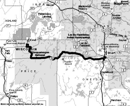
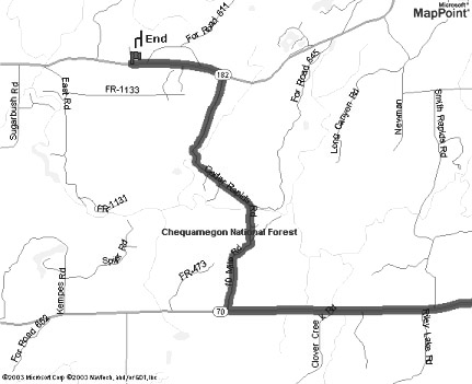
Right (West) onto SR-70 West and drive 28.5 miles.
Right (North) onto Forest Road 149 also known as 10 Mile Road and go 1.3 miles
Road name changes to Cedar Rapids Road, keep going another 3.3 miles to SR-182
Left (West) onto SR-182 West. Over the next 2 miles or so, you will pass Camp 9
Road (Rt 908) on the right and Forest Road 529 on the right. After FR-529, on
your left you will see a small clearing and a very tall tower. You made it! Turn
left and park.
If you pass FR 512 on the right, or East Road on the left, you have gone to far.
 |
 |
Willow Creek Uplands Site and Flux Tower
Driving time: 25 miles, about 40 minutes
Leave Kemp down Kemp Woods Road (2 miles)
Left (North) onto SR 47 North and go 3 miles to traffic light for Highway J
Left (West) onto Highway J West and go 1 mile to traffic light for US 51
Left (South) onto US 51 South and go < 1 mile to traffic light for State Route
70
Right (West) onto SR-70 West and drive about 11 miles
Midway between Fifield and Woodruff on Hwy 70 you will pass a bar named Musky
Jack's on the right. Then you will see Pike Lake on the right
Immediately afterwards, turn left (south) onto FR-132 South (also called Pike
Lake Road)
Travel about 5 miles to FR-130
Turn left (East) onto FR-130 and drive about 1/4 mile
Turn left (South) onto FR-130D (2-track road) and drive 1/2 mile
You will first pass the generator shelter on the left (1/4 mile) and then the
tower and shed
Lost Creek Wetlands Site and Flux Tower
Driving time: 25 miles, about 40 minutes
Leave Kemp down Kemp Woods Road (2 miles)
Left (North) onto SR 47 North and go 4 miles to traffic light for US 51
Continue on SR-47 another 14 miles or so toward Lac Du Flambeau and SR-182
About 1/4 mile after SR-47 intersects with SR-182 (on the left) is the alder
wetland.
There is a gated snowmobile trail on the south side of the 47 that will take you
out to the site.
You should also be able to see the tower from the highway.
Sylvania Old Growth Site and Flux Tower
Driving time: 40 miles, about 1 hour
Leave Kemp down Kemp Woods Road (2 miles)
Left (North) onto SR 47 North and go 4 miles to traffic light for US 51
Right (North) onto US 51 and go 6 miles to County Road M
Right (North/East) onto CR-M and go 8 miles to Boulder Junction
Turn left to continue on CR-M through Boulder Junction and go through town (<
0.5 mile)
Turn right again to continue on CR-M and go 7 miles until the road ends at CR-B
Right (East) onto CR-B and go 12 miles
You will pass a sign for Bent's Camp on the left and then Spring Creek Road on
the left
The next major road after Spring Creek Road on the left is Thousand Island Lake
Road (formerly County Z)
Left (North) onto Thousand Island Lake Road
Travel 4 miles or so until you get to a major intersection with lots of white
signs
Turn Right (North) to continue traveling on Thousand Island Lake Road
In the next few miles, you will pass Jay's Resorts and then Wilderness Bay Lodge
After a sharp curve to the right, stop when you get to a sign for Snap Jack Lake
There is a paved road to the left that goes to Snap Jack Lake
Turn right onto the 2-track road to get to the site
Park at the forest service gate and walk down trail about 1/2 mile to an
electrical utility box on the left, the tower and control shed are pass the
utility box