Chequamegon Ecosystem-Atmosphere Study (ChEAS) 2005 Meeting
Kemp Natural Resources
Station, Woodruff, WI
June 1 – June 2, 2005
Getting
to Kemp Natural Resources Station
Kemp Natural Resources
Station is located in the northwoods of Wisconsin
near the town of Woodruff, WI
around 200 miles north of Madison, Wisconsin,
and 250 miles northwest of Minneapolis, MN.
See map below for details.
By Air: The nearest commercial airport to Kemp is located in
Rhinelander, WI, about 30 miles to the south. Rhinelander airport is
served by Northwest Airlines / Mesaba Airlines via
Minneapolis/St. Paul International Airport and by Midwest Express / Skyway
Airlines via George Mitchell
International Airport
in Milwaukee, WI.
The next closest commercial airport is Wausau, WI,
about 70 miles from Kemp. Wausau
airport is served by Northwest Airlines / Mesaba
Airlines via Minneapolis/St. Paul International Airport or Detroit
/ Wayne County
International Airport,
by Midwest Express / Skyway Airlines via George
Mitchell International
Airport in Milwaukee,
WI, and by United Express via Chicago
O'Hare. Rental cars are available at either airport (National or Avis in
Rhinelander, National, Avis, Budget or Hertz in Wausau).
Most major airlines serve the Dane County Regional Airport in Madison, WI (4
hour drive), the Minneapolis / St. Paul International Airport (4-5 hour drive),
George Mitchell International Airport in Milwaukee, WI (5-6 hour drive), or
Chicago O'Hare International Airport or Midway (6 hour drive).
By Car:
From Chicago
O'Hare (total 6 hours to Kemp): Follow signs for Interstate 90 West toward Rockville,
IL and Madison,
WI. Follow I-90 about 130 miles to Madison.
Follow directions below (from Madison).
From Milwaukee
airport (total 5 hours): Follow signs for Interstate 94 West. Head
west on I-94 for about 70 miles to Madison.
Follow directions below (from Madison).
From Madison
(total 4 hours): Follows signs for Interstate 39 North. Head north for
about 140 miles until you reach Wausau.
Continue on I-39/US-51. North of Wausau, I-39 becomes US-51 North.
Follow directions below (from US-51 North).
From Wausau
airport (Mosinee, WI)
(total 1.5 hours): Turn left (west) onto WI-153 as you exit the airport.
Follow signs for Interstate 39 North. Head north for about 15 miles until
you reach Wausau. Continue on
I-39/US-51. North of Wausau, I-39 becomes US-51 North. Follow
directions below (from US-51 North).
From Minneapolis/St. Paul airport (total 4-5
hours):
Fast way: Follow signs for
I-494 East to St. Paul. In
about 15 miles, take the exit for I-94 East. Take I-94 for about 70 miles
until you reach Wisconsin exit 52 for state route
29. Head north on state route 29 for 20 miles toward Chippewa
Falls. Follow
signs in Chippewa Falls (right at light, merge onto exit ramp after bridge) to continue
eastward on state route 29. Drive another 90 miles on state route
29 to Wausau, WI.
Turn left onto US-51 North. Follow directions below (from US-51 North).
Scenic Way (slightly longer,
takes you through Chequamegon
National Forest): Follow signs for Minneapolis
(MN-55 West to MN-62 West). In four miles, exit onto Interstate 35W North toward downtown Minneapolis.
I-35W eventually becomes I-35 north of the Twin
Cities. Continue on I-35 about 35 miles to exit 165 for MN-70. Head
east on Minnesota state route 70
to Wisconsin, where it becomes Wisconsin
state route 70. Drive a total of around 160 miles on SR-70 until you
intersect US-51 in Woodruff, WI. Turn left onto US-51, and follow
directions below (from US-51 North).
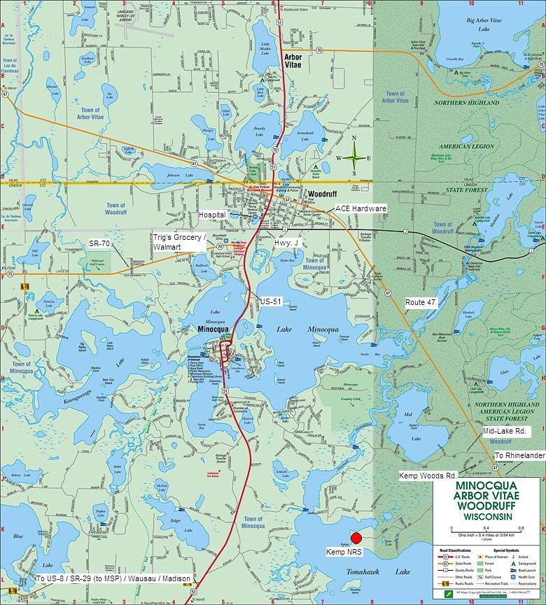
From US-51 North (south of Minocqua / Woodruff)
(total 1-1.5 hours): From Wausau, head north on US-51 about 70 miles.
Drive through Minocqua. After Minocqua, you will pass a traffic light for
state route 70. Soon afterwards is the traffic light for County Road J
(if you miss J, turn right at the next light for SR-47 and skip the next 3
sentences). Turn right onto Road J. Drive about 1 mile to the next
traffic light. Turn right (south) onto state route 47. Drive 3
miles. On your right immediately after Midlake Road, will be Kemp
Woods Road. Turn right onto Kemp
Woods Road. Follow directions below (from Kemp
Woods Road).
From Rhinelander airport (total .5 hour): Turn
left at the airport exit to go east on US-8. Drive 2 miles to state route
47. Turn left to head north on state route 47. Drive north 15 miles
and keep an eye out on your left for Kemp Woods Road
(about 3.25 miles after the town of Lake
Tomahawk). Turn left onto Kemp Woods Road.
Follow directions below (from Kemp Woods Road).
From Kemp Woods Road
(total 5 minutes): Kemp Natural Resources Station is at the end of Kemp
Woods Road, about 2 miles. The pavement will
end. Continue driving into the station another 0.5 miles. Drive
past a white house on your left. You will continue past many downed trees
from the summer 2000 blowdown. When you reach a
fork in the road, continue straight (right fork, following signs for Lodge)
until you reach a parking area and shelter. Park here.
The lab and office are behind you to the left. The kitchen building and
main lodge are straight ahead. The small cabin is down the hill past the
lab. The boathouse is to your right.
Local area map (click on any quadrant to zoom in, map
courtesy of http://www.minocqua.org ):
Return to meeting main page